| | Published December 8th, 2010
| Is a Pathway Possible Through Downtown?
| | By Cathy Tyson | 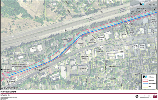 | | Segment 1
|
A friendly, relaxed group contemplated the possibility of having a bike and pedestrian pathway through the heart of downtown Lafayette at a recent workshop. At issue is the EBMUD Aqueduct right-of-way land that runs behind the Veterans Hall, continues between highway 24 and Safeway and ends at Brown Avenue.
 The workshop was part of a feasibility study funded by a CalTrans Community Planning Grant to determine the viability of constructing a pathway that would address topography concerns and challenging intersection crossings and in the process provide a safe functional pathway for walkers and cyclists and that is compliant with the Americans with Disabilities Act. The City of Lafayette hired consultant Alta Planning + Design along with Mark Thomas and Company and Fehr & Peers to complete the study, but is also partnering with stakeholders CalTrans, EBMUD, the East Bay Regional Park District and BART.
"What is possible, what would it cost and why is it important," said Project Manager Ian Moore of Alta Planning + Design, referring to the goal of the study.
Participants at the December 1 workshop were asked how they would use the site - for recreation or commuting, on foot or on bicycle, along with other topics on each of the four sections of pathway. So far there are a lot of questions, but only some answers. In the near future, Moore anticipates quantifying options, and identifying potential sources of funding.
The EBMUD easement is wide, but includes a very large, very old water pipe that serves the community and beyond. This, coupled with some steep slopes, make for significant structural limitations. Add to that several intersections that would be challenging to cross without a traffic signal or in one instance, a bridge, contribute to the project's complexity.
One of the first issues is determining what type of pathway is appropriate for the sections of the proposed path; choices include Class 1 Bike Path, Multi-Purpose Trail and Park/Open Space trail (see illustration). Each has benefits, limitations and differing costs of construction.
"This is great - doing a study to determine real costs and opportunities," said Jim Townsend, East Bay Regional Park District Trails Development Program Manager, adding, "It's a challenging project with undetermined utility."
Commenting on the usefulness of what will likely be an expensive (even if government funded) project, one participant, an avid bicyclist, questioned if this is the best use of money - could Concord put it to better use, or if it should go toward paying down the deficit.
Look for a final report with specifics in the fall of 2011. All of the documents produced to date are available at www.lafayettepathway.com City staff want to hear from you about the project - check the website to see how to contribute.
|
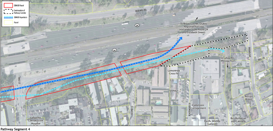 | | Segment 4
Image courtesy Ian Moore, Alta Planning + Design
| | | | | | | | | | | Advertisement | | |
| | | | | | Comments | | | | | |  | | |
| | |  | | |
| | | | |

