| | Published March 26th, 2014
| Walking in SunshineLafayette trail maps get thoughtful upgrade just in time for spring
| | By Cathy Tyson | 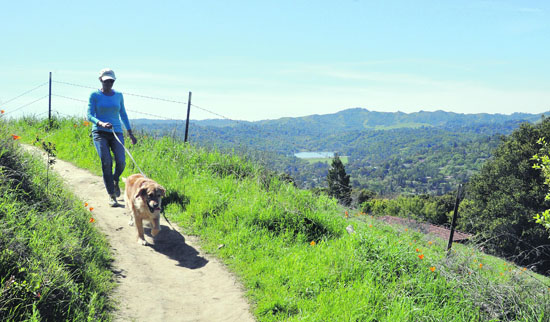 | | Wendy Scheck and furry companion Amberite recently enjoyed a midday hike on the Briones-to-Mt. Diablo Regional Trail. Photo Andy Scheck |
The hills are popping with poppies! Precious late-winter rains turned Lamorinda green, at least for a little while, as spring arrives in full bloom. If you're in the mood to take it all in you'll be glad to know that taking a hike just got easier, or rather, more informative, thanks to Lafayette's trail maps project.
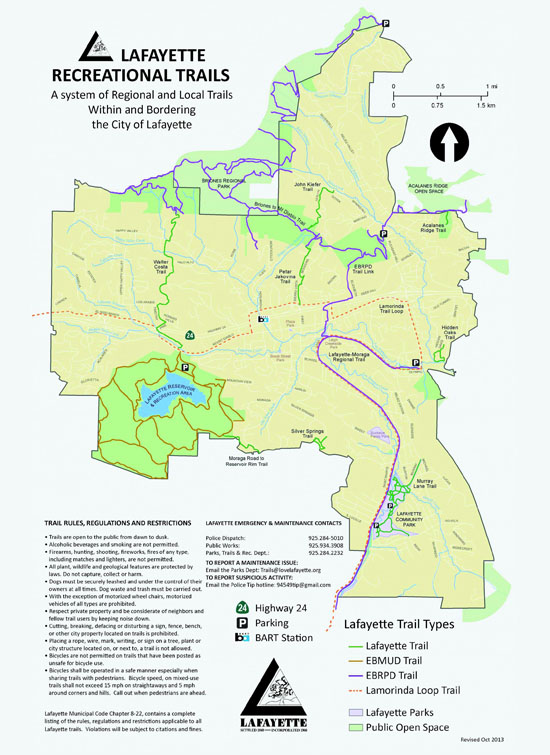
 Looking to avoid steep hills? Then these new and improved maps are your friends - that crucial information, along with trail length, surface, terrain and parking information is now a click away via the city's website; printed maps are available at the Parks and Recreation office at the Lafayette Community Center and other locations noted below. Updated trail maps range from the challenging, yet scenic, Walter Costa Trail (a steep, more than two-mile trek) to the much more moderate Silver Springs Trail to the flat, one-mile Hidden Oaks Trail. Both the rigorous Rim and lower trail maps of the Lafayette Reservoir, along with the East Bay Regional Park District's map of the Lafayette-Moraga Trail, can also be found on the website.
Active residents have Lafayette's trails subcommittee to thank along with whiz kid intern Emily "Chippie" Kislik. Looking for someone with a technical and mapping background, the subcommittee figured UC Berkeley might be a great resource - there they found Kislik, who recently graduated with a Bachelor of Science degree from Cal's College of Natural Resources and is now a contractor at NASA's Applied Science DEVELOP Program at the Ames Research Center.
"Her impressive knowledge of GIS (Geographic Information Systems) was used to update several city maps including the City of Lafayette Trails Master Plan Map, a comprehensive recreational trails map and several individual trail maps," said Jennifer Russell, Parks Trails and Recreation director. "Chippie is all about earth science and she brought passion and dedication to her mapping project."
Upgrading Lafayette's many trails maps took over a year and required a dedicated team effort from the many volunteers on the Parks Trails and Recreation committee, staff and of course the clever intern. Each tri-fold map includes a clear topographical map with elevations marked, rules and restrictions, emergency contact phone numbers and lovely photographs from the trail. Namesake trails include a photo of the local luminary - in the case of the Walter Costa and Petar Jakovina trails, photos were provided by the Lafayette Historical Society.
With this free resource available to all, longtime Park Trails and Recreation member and avid hiker Allison Hill hopes more residents will enjoy the great outdoors. She points out that there have been no incidents on hiking trails and that even when crossing paths with fellow hikers, a rare occurrence, folks sharing the trails are generally very friendly.
When the Petar Jakovina trail was dedicated, Hill was in attendance and described him as "such a gentleman - he took us all to lunch afterward," at Petar's, of course.
Most of the trails are on private property that the city has an easement over, which is good for property owners, explained Hill. Especially when damage occurs, such as the recent slide due to heavy rains at the Moraga-Lafayette border, in which case the cities split the cost of repairs.
With nature's local bounty beckoning, and helpful maps to guide the way, it's time to grab some comfortable shoes and help celebrate spring. For hikers looking for company the Lafayette Hiking Group welcomes all; for information about their roughly bi-monthly hikes in the area go to lafayettehiking@comcast.net. New maps and the hiking group's scheduled walks may be found on the city website at www.lovelafayette.com, go to Parks and Recreation, then Trails; maps can also be found at the Community Center, 500 St. Mary's Road, the Lafayette Library and Learning Center, the city offices at 3675 Mt. Diablo Boulevard, #210 or at the Chamber of Commerce, 100 Lafayette Circle, suite 103.
|
 | | | | | | | | | | | |