| | Published August 14th, 2013
| Exploring Moraga's Less Traveled Trails
| | By Sophie Braccini | 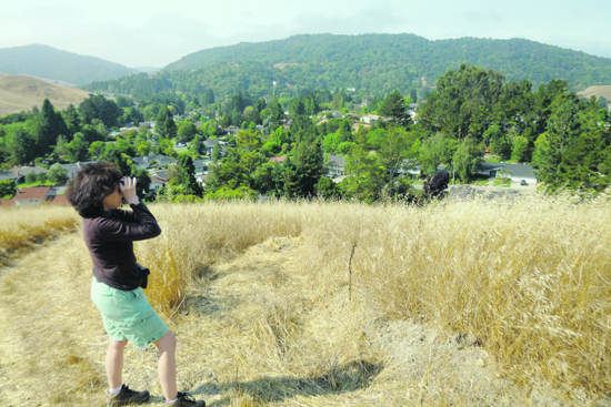 | | Moraga Parks and Recreation Commission chair Karen Reed enjoys a spectacular view from the Old Moraga Ranch Trail. Photo Sophie Braccini
|
In the all-time favorite Moraga elementary school song "The Hills of Moraga," it is said that the hills "are calling to me." The hills and trails of Moraga are among the first things that come to mind for many when describing this bucolic town. But do residents know the hills and trails that well? Not according to passionate hiker Karen Reed, the chair of the Parks and Recreation Commission.
 Reed says that some trails are seldom traveled, some of the surrounding hills' beauty ignored. Two of Moraga's less traveled trails are Old Moraga Ranch Trail and the eastern part of Kings Canyon Loop Trail. These trails are not for "sissies" - this is serious hiking with steep ups and downs, but the treks are as magical as the views. Up these trails you'll be on top of the world.
"Moraga Ranch Trail may be less known because it starts in the middle of nowhere and ends in the middle of nowhere," said Reed. On a recent bright Saturday morning, Reed started out with a small group of hikers at an easy access point to the trail, off Sanders Ranch Road. Parking along Camino Pablo, close to the Sanders Ranch guard shack, the group entered the property and turned right, walking along the west side of the road. (Pedestrians are allowed in the gated community.) The trail marker was less than a quarter mile in, on the left hand side. "If you look at the map, the trail starts off Rocky Ridge Trail," said Reed. "It is well marked, but this access is easy enough."
The trail has unmistakable creek charm, crisscrossing Moraga Creek - a vivacious stream, still running in July - and taking hikers over several bridges nestled among trees. Soon hikers began the arduous trip up the hills, wandering in the back of Sanders Ranch and behind Larch, before heading toward Saint Mary's College.
"The difference of elevation is quite substantial," said Reed. "The town's elevation is about 500 feet and the trail reaches the highest point in Moraga, Saint Mary's Peak; its elevation just below 1,200 feet."
The trail, which is the oldest and least used, according to Reed, continues through valleys and cattle grazing areas, some of it private; it is a public trail maintained by the East Bay Regional Park District, which keeps it wide enough and cuts back the weeds, though one needs to be vigilant to stay clear of poison oak. Hikers continued past the college and ended at Las Trampas Creek and Bollinger Canyon Road. Once at the top of Saint Mary's Peak, hikers were met with magnificent views of the entire area.
Another less well-known Moraga trail, noted Reed, is the eastern portion of Kings Canyon Loop Trail, a path less traveled than the western portion that connects Rancho Laguna trail head to the Valle Vista Staging Area along the Upper San Leandro Reservoir.
Hikers used to traveling along the western section of the trail, starting from Rancho Laguna Park along the reservoir, should take a left after they pass the cattle gate. The sign on the left clearly states "Kings Canyon Loop Trail." The eastern part of the loop is just to the right; the 1.3-mile trail does not connect directly to the western side at Valle Vista Staging Area. To make an actual loop, turn right when the path crosses Rimer Creek Trail, which takes hikers back to Kings Canyon after 0.2 miles, less than a mile from the Staging Area.
The hike requires more sturdy footwear than standard walking shoes. The change in elevation is significant, but there, too, the expanse of the views richly rewards the brave hiker. On the loop, hikers might meet horsemen and their horses as these wider trails are open to equestrians. This trail is part of the East Bay Municipal Utility District's watershed trails network and requires a permit to be hiked.
Reed believes that the 35-plus miles of trails available to walkers and hikers in Moraga are underused; notable exceptions include the Lafayette-Moraga Trail and the Mulholland Ridge Trail. She recommends the trail guide published by the Moraga Park Foundation that can be found online at www.moragaparks.org/TrailsBooklet.pdf. It gives a general map of the trails and a detailed description of each of them. EBMUD trail maps can be found at: http://www.ebmud.com/sites/default/files/pdfs/south%5B1%5D.pdf.
|
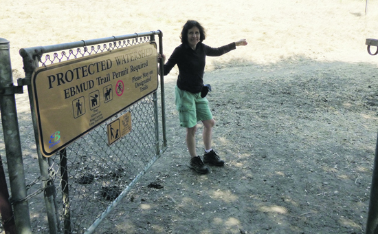 | | Karen Reed showing the entrance point to the eastern side of the Kings Canyon Loop Trail. Photo Sophie Braccini
| 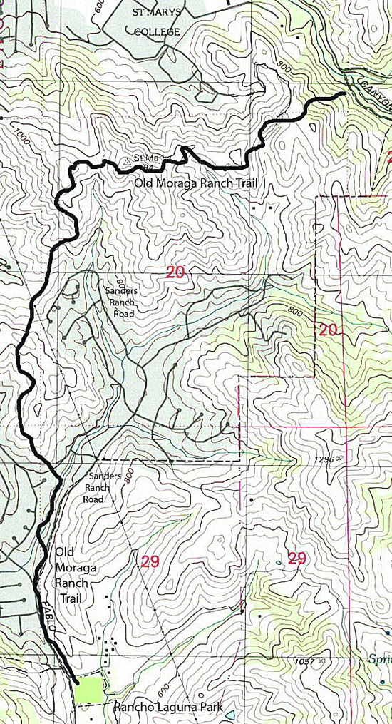 | | Trail map can be found in the Moraga Area Trails Guidebook 2013
| 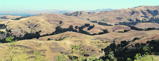 | | View over Saint Mary's College and Bollinger Canyon Photo Andy Scheck
| | | | | | | | | |
| | | print story
Before you print this article, please remember that it will remain in our archive for you to visit anytime.
download pdf
(use the pdf document for best printing results!) | | | Comments | | |
| | | | | | | | | | | | | | | | |

